
Rapperswil-Jona topographic map
Interactive map
Click on the map to display elevation.
About this map
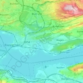
Name: Rapperswil-Jona topographic map, elevation, terrain.
Location: Rapperswil-Jona, Wahlkreis See-Gaster, St. Gallen, Switzerland (47.20817 8.79561 47.25151 8.91918)
Average elevation: 468 m
Minimum elevation: 394 m
Maximum elevation: 780 m
Other topographic maps
Click on a map to view its topography, its elevation and its terrain.
Schänis
Switzerland > St. Gallen > Wahlkreis See-Gaster
Schänis, Wahlkreis See-Gaster, St. Gallen, Switzerland
Average elevation: 725 m
Obersee
Switzerland > St. Gallen > Wahlkreis See-Gaster > Rapperswil-Jona
Obersee, Rapperswil-Jona, Wahlkreis See-Gaster, St. Gallen, Switzerland
Average elevation: 535 m