
St Anne topographic map
Interactive map
Click on the map to display elevation.
About this map
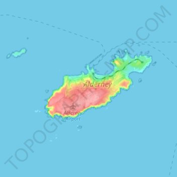
Name: St Anne topographic map, elevation, terrain.
Location: St Anne, Alderney, Guernsey (49.67479 -2.24362 49.75479 -2.16362)
Average elevation: 5 m
Minimum elevation: -1 m
Maximum elevation: 88 m
Other topographic maps
Click on a map to view its topography, its elevation and its terrain.
English Channel
English Channel, Albert Mews, St Anne, Alderney, Guernsey
Average elevation: 55 m
Raz Island
Guernsey > Alderney > St Anne > Longis
Raz Island, Longis, St Anne, Alderney, Guernsey
Average elevation: 7 m