
Chirayinkeezhu topographic map
Interactive map
Click on the map to display elevation.
About this map
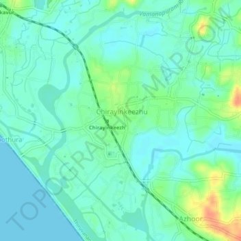
Name: Chirayinkeezhu topographic map, elevation, terrain.
Location: Chirayinkeezhu, Thiruvananthapuram, Kerala, 695309, India (8.63959 76.76783 8.67959 76.80783)
Average elevation: 11 m
Minimum elevation: 0 m
Maximum elevation: 42 m
Other topographic maps
Click on a map to view its topography, its elevation and its terrain.
Attingal
India > Kerala > Chirayinkeezhu
Attingal, Chirayinkeezhu, Thiruvananthapuram District, Kerala, 695100, India
Average elevation: 25 m
Kilimanoor
India > Kerala > Chirayinkeezhu > Kilimanoor
Kilimanoor, Chirayinkeezhu, Thiruvananthapuram, Kerala, 695600, India
Average elevation: 59 m
Alamcode
India > Kerala > Chirayinkeezhu
Alamcode, Chirayinkeezhu, Thiruvananthapuram District, Kerala, 695102, India
Average elevation: 29 m