
Moyen-Chari topographic map
Interactive map
Click on the map to display elevation.
About this map
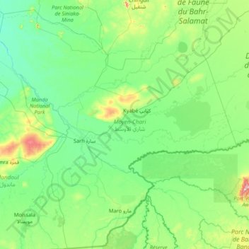
Name: Moyen-Chari topographic map, elevation, terrain.
Location: Moyen-Chari, Chad (8.01950 17.38100 10.58800 19.99211)
Average elevation: 391 m
Minimum elevation: 340 m
Maximum elevation: 865 m
Other topographic maps
Click on a map to view its topography, its elevation and its terrain.
Missou
Chad > Logone Occidental > Koutou Mare
Missou, Koutou Mare, Logone Occidental, Chad
Average elevation: 396 m
Sangaria
Chad > Hadjer-Lamis > Guitté > Sangaria
Sangaria, Guitté, Hadjer-Lamis, Chad
Average elevation: 284 m
Moundou
Chad > Logone Occidental > Moundou
Moundou, Logone Occidental, 1234, Chad
Average elevation: 438 m