
Saint Patrick topographic map
Interactive map
Click on the map to display elevation.
About this map
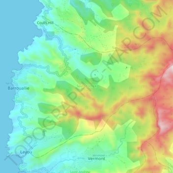
Name: Saint Patrick topographic map, elevation, terrain.
Location: Saint Patrick, Saint Vincent and the Grenadines (13.20159 -61.27938 13.27445 -61.18826)
Average elevation: 301 m
Minimum elevation: -1 m
Maximum elevation: 981 m
Other topographic maps
Click on a map to view its topography, its elevation and its terrain.
Arnos Vale
Saint Vincent and the Grenadines > Saint George
Arnos Vale, Saint George, VC0100, Saint Vincent and the Grenadines
Average elevation: 72 m
Mustique
Saint Vincent and the Grenadines > Grenadines > Dovers
Mustique, Dovers, Grenadines, Saint Vincent and the Grenadines
Average elevation: 9 m
Bequia
Saint Vincent and the Grenadines
Bequia, Grenadines, Saint Vincent and the Grenadines
Average elevation: 16 m
Windward Islands
Saint Vincent and the Grenadines
Windward Islands, Saint Vincent and the Grenadines
Average elevation: 0 m
Vermont
Saint Vincent and the Grenadines > Vermont
Vermont, Saint Andrew, VC0100, Saint Vincent and the Grenadines
Average elevation: 298 m
Anchroage
Saint Vincent and the Grenadines
Anchroage, Saint Vincent and the Grenadines
Average elevation: 45 m
Kingstown
Saint Vincent and the Grenadines > Saint George > Kingstown
Kingstown, Saint George, VC0100, Saint Vincent and the Grenadines
Average elevation: 108 m
Grenadines
Saint Vincent and the Grenadines
Grenadines, Saint Vincent and the Grenadines
Average elevation: 1 m