
County Carlow topographic map
Interactive map
Click on the map to display elevation.
About this map
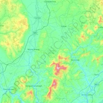
Name: County Carlow topographic map, elevation, terrain.
Location: County Carlow, Leinster, Ireland (52.46359 -7.10794 52.91802 -6.50494)
Average elevation: 126 m
Minimum elevation: 0 m
Maximum elevation: 789 m
The soils of the county are mostly derived from glacial till, rather than solid bedrock geology. These typically consist of a mix of clay, sand and gravel. Occasionally glacial melt-water would form a long ridge of sand and gravel known as an esker. One such example is preserved within the county and is a proposed natural heritage area, referred to as the Ballymoon Esker. The north of the county is generally flat, while central and southern Carlow are characterised by an undulating to rolling topography which becomes progressively hillier towards the south and east. The Blackstairs Mountains are the highest and most extensive upland area, with Mount Leinster rising to 794 m (2,605 ft), making it the highest point in both Carlow and Wexford and the seventh highest county top in Ireland.
Other topographic maps
Click on a map to view its topography, its elevation and its terrain.
Meenane
Meenane, Watergrasshill, Municipal District of Cobh, County Cork, Munster, Ireland
Average elevation: 173 m
Carrowmore
Carrowmore, Kilmacowen ED, Sligo Municipal Borough District, County Sligo, Connacht, Ireland
Average elevation: 36 m
Ballinasloe
Ballinasloe, County Galway, Connacht, Ireland
Average elevation: 46 m
Curraghboy
Curraghboy, Castleffrench ED, Ballinasloe Municipal District, County Galway, Connacht, Ireland
Average elevation: 53 m
Corballis
Corballis, Donabate DED 1986, Fingal, County Dublin, Leinster, Ireland
Average elevation: 3 m
Murreagh
Murreagh, Kenmare Municipal District, County Kerry, Munster, V92 P681, Ireland
Average elevation: 37 m
Grand Canal - Barrow Line
Ireland > County Kildare > Athy
Grand Canal - Barrow Line, Athy, Athy Urban West ED, The Municipal District of Athy, County Kildare, Leinster, R14 EH50, Ireland
Average elevation: 60 m
Clooney
Clooney, Killaloe Municipal District, County Clare, Munster, Ireland
Average elevation: 57 m
Dunfanaghy
Dunfanaghy, County Donegal, F92 H0CY, Ireland
Average elevation: 23 m
Doonbeg
Doonbeg, West Clare Municipal District, County Clare, Munster, Ireland
Average elevation: 11 m
Ballyconneely
Ballyconneely, Conamara Municipal District, County Galway, Connacht, Ireland
Average elevation: 8 m
Ballyliffin
Ballyliffin, Inishowen Municipal District, County Donegal, Ulster, Ireland
Average elevation: 76 m
Ballyjamesduff Municipal District
Ballyjamesduff Municipal District, County Cavan, Ulster, Ireland
Average elevation: 100 m
Burrow
Burrow, Kilcumeragh ED, The Municipal District of Tullamore, County Offaly, Leinster, Ireland
Average elevation: 64 m
Lisfannan
Lisfannan, Burt ED, Inishowen Municipal District, County Donegal, Ireland
Average elevation: 48 m
Lahinch
Lahinch, Ennistimon ED, West Clare Municipal District, County Clare, Munster, Ireland
Average elevation: 35 m
Dough
Dough, Crookhaven ED, West Cork, County Cork, Munster, Ireland
Average elevation: 35 m
Bartragh
Bartragh, Castleconor West Electoral Division, Ballymote-Tubbercurry Municipal District, County Sligo, Connacht, Ireland
Average elevation: 6 m
Dooaghs
Dooaghs, Caragh ED, Kenmare Municipal District, County Kerry, Munster, Ireland
Average elevation: 10 m
Murvagh Lower
Murvagh Lower, Ballintra ED, Donegal Municipal District, County Donegal, Ireland
Average elevation: 2 m
Cruit Island
Cruit Island, Rutland ED, Glenties Municipal District, County Donegal, Ireland
Average elevation: 6 m
Rosses Point
Rosses Point, County Sligo, Connacht, Ireland
Average elevation: 8 m
Bandon
Bandon, The Municipal District of Bandon-Kinsale, County Cork, Munster, Ireland
Average elevation: 59 m
Carrowbunnaun
Carrowbunnaun, Knockaree ED, Sligo Municipal Borough District, County Sligo, Connacht, Ireland
Average elevation: 36 m
Termonfeckin
Termonfeckin, Termonfeckin ED, The Borough District of Drogheda, County Louth, Leinster, Ireland
Average elevation: 16 m
Bearlough
Bearlough, Toomour ED, Ballymote-Tubbercurry Municipal District, County Sligo, Connacht, Ireland
Average elevation: 72 m
Croaghross
Ireland > County Donegal > Letterkenny
Croaghross, Greenfort ED, Letterkenny, County Donegal, Ireland
Average elevation: 25 m
Illanoona
Illanoona, Corraun Achill ED, Westport-Belmullet Municipal District, County Mayo, Connacht, Ireland
Average elevation: 20 m
Rosses Upper
Rosses Upper, Drumcliff West ED, Sligo Municipal Borough District, County Sligo, Connacht, Ireland
Average elevation: 8 m
Baltray
Baltray, Termonfeckin ED, The Borough District of Drogheda, County Louth, Leinster, Ireland
Average elevation: 3 m
Donabate
Donabate, Semple Woods, Donabate DED 1986, Fingal, County Dublin, Leinster, Ireland
Average elevation: 6 m
Stradbally
Stradbally, Stradbally ED, The Municipal District of Graiguecullen — Portarlington, County Laois, Leinster, Ireland
Average elevation: 92 m
Castlegregory
Castlegregory, Kenmare Municipal District, County Kerry, Munster, V92 F6NX, Ireland
Average elevation: 17 m
Kilgarvan
Kilgarvan, Kilgarvan ED, Kenmare Municipal District, County Kerry, Munster, Ireland
Average elevation: 71 m
Mohill
Mohill, Mohill ED, Carrick-on-Shannon Municipal District, County Leitrim, Connacht, N41 R9T3, Ireland
Average elevation: 60 m
Castletown
Castletown, The Municipal District of Kells, County Meath, Leinster, Ireland
Average elevation: 72 m
Mount Lucas
Mount Lucas, Esker ED, The Municipal District of Edenderry, County Offaly, Leinster, R35 XW10, Ireland
Average elevation: 76 m
Yardland
Yardland, Arklow No 1 Urban ED, The Municipal District of Arklow, County Wicklow, Leinster, Ireland
Average elevation: 23 m