
Roatán topographic map
Interactive map
Click on the map to display elevation.
About this map
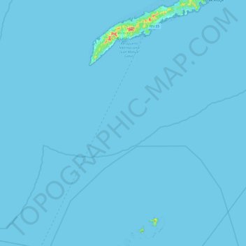
Name: Roatán topographic map, elevation, terrain.
Location: Roatán, Bay Islands, 33166, Honduras (16.26676 -86.60303 16.38814 -86.41857)
Average elevation: 7 m
Minimum elevation: -1 m
Maximum elevation: 217 m
Other topographic maps
Click on a map to view its topography, its elevation and its terrain.
Isla de Roatán
Honduras > Bay Islands > José Santos Guardiola > Roatán
Isla de Roatán, Roatán, José Santos Guardiola, Bay Islands, Honduras
Average elevation: 3 m
Útila
Honduras > Bay Islands > Coxen Hole
Útila, Coxen Hole, Bay Islands, THE BAY ISLANDS, Honduras
Average elevation: 1 m