
Suc au May topographic map
Interactive map
Click on the map to display elevation.
About this map
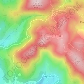
Name: Suc au May topographic map, elevation, terrain.
Average elevation: 773 m
Minimum elevation: 593 m
Maximum elevation: 917 m
Other topographic maps
Click on a map to view its topography, its elevation and its terrain.
Touvent
France > Nouvelle-Aquitaine > Corrèze > Chaumeil
Touvent, Chaumeil, Ussel, Corrèze, Nouvelle-Aquitaine, France métropolitaine, 19390, France
Average elevation: 649 m
Malfonf
France > Nouvelle-Aquitaine > Corrèze > Chaumeil
Malfonf, Chaumeil, Ussel, Corrèze, Nouvelle-Aquitaine, France métropolitaine, 19390, France
Average elevation: 690 m
Freysselines
France > Nouvelle-Aquitaine > Corrèze > Chaumeil
Freysselines, Chaumeil, Ussel, Corrèze, Nouvelle-Aquitaine, France métropolitaine, 19390, France
Average elevation: 692 m