
Frederiksted topographic map
Interactive map
Click on the map to display elevation.
About this map
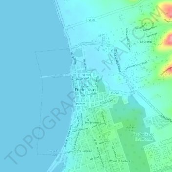
Name: Frederiksted topographic map, elevation, terrain.
Average elevation: 14 m
Minimum elevation: -2 m
Maximum elevation: 110 m
Rainforests are located on this western side of St. Croix due to the topography and 1,400 foot peaks and the tradewinds. This rainforest climate is unique to the Frederiksted side of St. Croix.
Other topographic maps
Click on a map to view its topography, its elevation and its terrain.
Saint Croix
United States > United States Virgin Islands > Saint Croix District > Christiansted
Saint Croix, Christiansted, Saint Croix District, United States Virgin Islands, United States
Average elevation: 11 m
Longford (Anna's Hope Village)
United States > United States Virgin Islands > Saint Croix District
Longford (Anna's Hope Village), Saint Croix District, United States Virgin Islands, 00824, United States
Average elevation: 49 m
Cartlon South
United States > United States Virgin Islands > Saint Croix District > Cartlon South
Cartlon South, Saint Croix District, United States Virgin Islands, 00840, United States
Average elevation: 23 m
Morningstar
United States > United States Virgin Islands > Saint Croix District > Morningstar
Morningstar, Saint Croix District, United States Virgin Islands, 00820, United States
Average elevation: 68 m
Virgin Islands
United States > United States Virgin Islands > Saint Croix District
Virgin Islands, Saint Croix District, United States Virgin Islands, United States
Average elevation: 2 m