
Leribe District topographic map
Interactive map
Click on the map to display elevation.
About this map
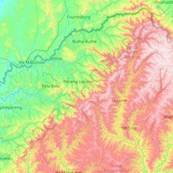
Name: Leribe District topographic map, elevation, terrain.
Location: Leribe District, 300, Lesotho (-29.37080 27.63897 -28.69374 28.79248)
Average elevation: 2,152 m
Minimum elevation: 1,483 m
Maximum elevation: 3,349 m
Other topographic maps
Click on a map to view its topography, its elevation and its terrain.
Botso Water Reseviour
Botso Water Reseviour, Leribe District, Lesotho
Average elevation: 2,285 m
PTC
Lesotho > Maseru District > Maseru
PTC, Maseru, Maseru District, 100, Lesotho
Average elevation: 1,649 m
Moyeni (Quthing)
Lesotho > Quthing District > Moyeni (Quthing)
Moyeni (Quthing), Quthing District, Lesotho
Average elevation: 1,644 m
Ha Long
Lesotho > Thaba-Tseka District > Ha Long
Ha Long, Thaba-Tseka District, Lesotho
Average elevation: 2,412 m
Thaba-Tseka
Lesotho > Thaba-Tseka District > Thaba-Tseka
Thaba-Tseka, Thaba-Tseka District, Lesotho
Average elevation: 2,216 m
Drakensberg
Drakensberg, Mokhotlong District, Lesotho
Average elevation: 3,286 m
Maqalika Dam
Lesotho > Maseru District > Maseru
Maqalika Dam, Maseru, Maseru District, 100, Lesotho
Average elevation: 1,540 m
Qacha's Nek
Lesotho > Qacha's Nek District > Qacha's Nek
Qacha's Nek, Qacha's Nek District, 600, Lesotho
Average elevation: 1,982 m