
Bragança topographic map
Interactive map
Click on the map to display elevation.
About this map
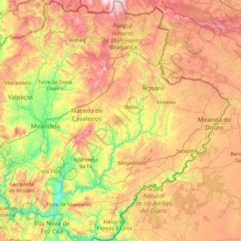
Name: Bragança topographic map, elevation, terrain.
Location: Bragança, Portugal (41.02454 -7.43189 41.99252 -6.18916)
Average elevation: 658 m
Minimum elevation: 103 m
Maximum elevation: 1,527 m
The district is composed of two distinct regions described in terms of its geographic differences: the northern areas, with the higher altitudes constitute the Terra Fria Transmontana (Cold lands), and the Alto Trás-os-Montes, where the landscape is dominated gentler slopes of the plateau; and the southern areas, the Terra Quente Trasmontana (Hot Lands), where the climate is milder, marked by the valleys of the Douro River and its tributaries. Its area allows a wide diversity of landscapes, and the district is known for its climatic differences (nine months of winter and three of heat), its rugged geomorphology, an aging population and urban to rural migration of its residents over time.
Other topographic maps
Click on a map to view its topography, its elevation and its terrain.
Lisbon
Portugal > Área Metropolitana de Lisboa > Lisbon
Benfica, Lisbon, Grande Lisboa, Área Metropolitana de Lisboa, Portugal
Average elevation: 110 m
Carvalheda
Portugal > Aveiro > Vale de Cambra > Roge
Carvalheda, Roge, Vale de Cambra, Aveiro, 3730-384, Portugal
Average elevation: 639 m
Maçãs de Dona Maria
Maçãs de Dona Maria, Alvaiázere, Leiria, Portugal
Average elevation: 288 m
Facho
Portugal > Braga > Vila Nova de Famalicão
Facho, Vila Nova de Famalicão, Braga, 4760-484, Portugal
Average elevation: 151 m
Cascata da Ermida
Portugal > Viana do Castelo > Ponte da Barca
Cascata da Ermida, Entre Ambos-os-Rios, Ermida e Germil, Ponte da Barca, Viana do Castelo, 4980-330, Portugal
Average elevation: 558 m
Vilar de Suente
Portugal > Viana do Castelo > Soajo
Vilar de Suente, Soajo, Arcos de Valdevez, Viana do Castelo, 4970-672, Portugal
Average elevation: 473 m
Pessegueiro do Vouga
Portugal > Aveiro > Sever do Vouga
Pessegueiro do Vouga, Sever do Vouga, Aveiro, Portugal
Average elevation: 188 m
Travanca de Lagos
Travanca de Lagos, Oliveira do Hospital, Coimbra, Portugal
Average elevation: 362 m
Medelim
Portugal > Castelo Branco > Idanha-a-Nova
Medelim, Idanha-a-Nova, Castelo Branco, Portugal
Average elevation: 395 m
Abade de Neiva
Abade de Neiva, Barcelos, Braga, Portugal
Average elevation: 109 m
Vale Covo
Portugal > Leiria > Bombarral e Vale Covo
Vale Covo, Bombarral e Vale Covo, Bombarral, Leiria, 2540-069, Portugal
Average elevation: 71 m
Idanha-a-Nova
Idanha-a-Nova, Castelo Branco, Portugal
Average elevation: 321 m
Veade
Portugal > Braga > Celorico de Basto
Veade, Celorico de Basto, Braga, 4880-195, Portugal
Average elevation: 213 m
Cerqueda
Portugal > Aveiro > Vale de Cambra
Cerqueda, Vila Chã, Codal e Vila Cova de Perrinho, Vale de Cambra, Aveiro, 3730-135, Portugal
Average elevation: 330 m
Afurada
Portugal > Porto > Vila Nova de Gaia
Afurada, Vila Nova de Gaia, Porto, 4400-587, Portugal
Average elevation: 49 m
Vila da Rua
Portugal > Viseu > Moimenta da Beira
Vila da Rua, Moimenta da Beira, Viseu, Portugal
Average elevation: 637 m
Malpica do Tejo
Malpica do Tejo, Castelo Branco, 6000-560, Portugal
Average elevation: 244 m
Figueira de Castelo Rodrigo
Figueira de Castelo Rodrigo, Guarda, Portugal
Average elevation: 537 m
Vilela
Portugal > Braga > Póvoa de Lanhoso
Vilela, Póvoa de Lanhoso, Braga, Portugal
Average elevation: 186 m