
Chukha Dzongkhag topographic map
Interactive map
Click on the map to display elevation.
About this map
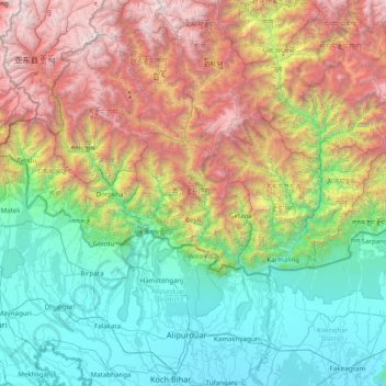
Name: Chukha Dzongkhag topographic map, elevation, terrain.
Location: Chukha Dzongkhag, Chukha District, Bhutan (26.30000 88.85000 27.70000 90.25000)
Average elevation: 1,632 m
Minimum elevation: 34 m
Maximum elevation: 5,506 m
Other topographic maps
Click on a map to view its topography, its elevation and its terrain.
Tsimasham
Bhutan > Chukha District > Bjagchhog Gewog > Tsimakha Tsimashysham
Tsimasham, Tsimakha Tsimashysham, Bjagchhog Gewog, Chukha District, Bhutan
Average elevation: 2,512 m
Pasakha
Bhutan > Chukha District > Samphelling Gewog > Pasakha
Pasakha, Samphelling Gewog, Chukha District, Bhutan
Average elevation: 483 m
Gedu
Bhutan > Chukha District > Bongo Gewog > Gedu
Gedu, Bongo Gewog, Chukha District, Bhutan
Average elevation: 1,900 m