
Poitou-Charentes topographic map
Interactive map
Click on the map to display elevation.
About this map
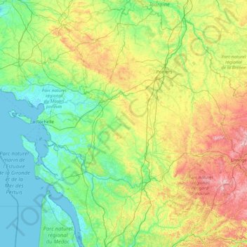
Name: Poitou-Charentes topographic map, elevation, terrain.
Location: Poitou-Charentes, Metropolitan France, France (45.08898 -1.56268 47.17592 1.21319)
Average elevation: 106 m
Minimum elevation: -2 m
Maximum elevation: 567 m
Other topographic maps
Click on a map to view its topography, its elevation and its terrain.
Château de Chaumont
France > Nouvelle-Aquitaine > Creuse > Mainsat > Chaumont
Average elevation: 566 m
Grande Rocheuse
France > Auvergne-Rhône-Alpes > Upper Savoy > Chamonix-Mont-Blanc
Average elevation: 3,245 m
Chez Landreau
France > Nouvelle-Aquitaine > Charente > Barbezieux-Saint-Hilaire
Average elevation: 62 m
Saint-Disdier
France > Provence-Alpes-Côte d'Azur > Hautes-Alpes > Le Dévoluy
Average elevation: 1,328 m
Lac du Mont-Cenis
France > Auvergne-Rhône-Alpes > Savoy > Val-Cenis
Mont-Cenis Lake is a lake located in the Mont-Cenis massif at an altitude of 1,974 meters (6,476 ft) in the municipality of Val-Cenis in France. It is situated at the top of the Cenise valley, on the Italian side of the Mont-Cenis pass, the most frequented passage on the Lyon-Turin-Milan axis during the Middle…
Average elevation: 2,096 m
Mont Blanc / Monte Bianco
France > Auvergne-Rhône-Alpes > Upper Savoy > Saint-Gervais-les-Bains
The climate is cold and temperate (Köppen climate classification Cfb), and is greatly influenced by altitude. Being the highest part of the Alps, Mont Blanc and surrounding mountains can create their own weather patterns. Temperatures drop as the mountains gain in height, and the summit of Mont Blanc is a…
Average elevation: 4,092 m
Pièce du Bois et des Fosses
France > Centre-Val de Loire > Indre > Saint-Maur
Average elevation: 162 m
Mont Blanc / Monte Bianco
France > Auvergne-Rhône-Alpes > Upper Savoy > Saint-Gervais-les-Bains
The climate is cold and temperate (Köppen climate classification Cfb), and is greatly influenced by altitude. Being the highest part of the Alps, Mont Blanc and surrounding mountains can create their own weather patterns. Temperatures drop as the mountains gain in height, and the summit of Mont Blanc is a…
Average elevation: 4,092 m
Pièce de la Fosse aux Joncs
France > Centre-Val de Loire > Indre > Saint-Maur
Average elevation: 161 m
Les Garrières
France > Nouvelle-Aquitaine > Dordogne > Saint-Saud-Lacoussière
Average elevation: 293 m
La Diablerie
France > Centre-Val de Loire > Indre-et-Loire > Chanceaux-sur-Choisille
Average elevation: 111 m
Le Carillon
France > Auvergne-Rhône-Alpes > Upper Savoy > Annecy > Cran-Gevrier
Average elevation: 501 m
Le Bois Bougemont
France > Brittany > Ille-et-Vilaine > La Guerche-de-Bretagne
Average elevation: 72 m
Gorgia
France > Provence-Alpes-Côte d'Azur > Maritime Alps > Saint-Étienne-de-Tinée
Average elevation: 1,513 m
Le Télégraphe
France > Centre-Val de Loire > Indre-et-Loire > Chambray-lès-Tours
Average elevation: 86 m
Barrage de Bimont
France > Provence-Alpes-Côte d'Azur > Bouches-du-Rhône > Saint-Marc-Jaumegarde
Average elevation: 354 m