
Liblar topographic map
Interactive map
Click on the map to display elevation.
About this map
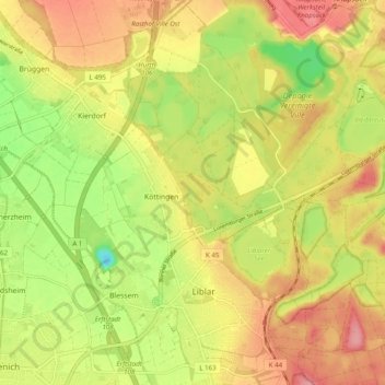
Name: Liblar topographic map, elevation, terrain.
Average elevation: 106 m
Minimum elevation: 51 m
Maximum elevation: 150 m
Other topographic maps
Click on a map to view its topography, its elevation and its terrain.
Bliesheim
Deutschland > Nordrhein-Westfalen > Erftstadt
Bliesheim, Erftstadt, Rhein-Erft-Kreis, Nordrhein-Westfalen, Deutschland
Average elevation: 117 m
Lechenich
Deutschland > Nordrhein-Westfalen > Erftstadt
Lechenich, Erftstadt, Rhein-Erft-Kreis, Regierungsbezirk Köln, Nordrhein-Westfalen, 50374, Deutschland
Average elevation: 107 m
Schloss Gymnich
Deutschland > Nordrhein-Westfalen > Erftstadt
Schloss Gymnich, Balkhausener Straße, Gymnich, Erftstadt, Rhein-Erft-Kreis, Regierungsbezirk Köln, Nordrhein-Westfalen, 50374, Deutschland
Average elevation: 88 m
Köttingen
Deutschland > Nordrhein-Westfalen > Erftstadt > Köttingen
Köttingen, Erftstadt, Rhein-Erft-Kreis, Nordrhein-Westfalen, 50374, Deutschland
Average elevation: 101 m