
Green River topographic map
Interactive map
Click on the map to display elevation.
About this map
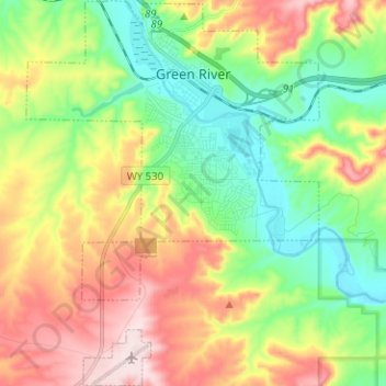
Name: Green River topographic map, elevation, terrain.
Average elevation: 1,985 m
Minimum elevation: 1,842 m
Maximum elevation: 2,195 m
Other topographic maps
Click on a map to view its topography, its elevation and its terrain.
Rock Springs
United States > Wyoming > Sweetwater County
Rock Springs, Sweetwater County, Wyoming, 82901, United States
Average elevation: 2,024 m
Green River
United States > Wyoming > Sweetwater County > Green River
Green River, Sweetwater County, Wyoming, 82935, United States
Average elevation: 2,015 m
Rock Springs
United States > Wyoming > Sweetwater County > Rock Springs
Rock Springs, Sweetwater County, Wyoming, 82901, United States
Average elevation: 2,057 m