
Klay topographic map
Interactive map
Click on the map to display elevation.
About this map
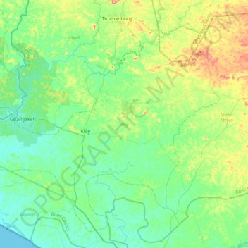
Name: Klay topographic map, elevation, terrain.
Location: Klay, Bomi County, Liberia (6.54010 -11.04908 6.87041 -10.66397)
Average elevation: 46 m
Minimum elevation: 0 m
Maximum elevation: 184 m
Other topographic maps
Click on a map to view its topography, its elevation and its terrain.
Sackie
Liberia > Bomi County > Senjeh > Sackie
Sackie, Senjeh, Bomi County, Liberia
Average elevation: 73 m
Montgonery Camp
Liberia > Bomi County > Montgonery Camp
Montgonery Camp, Senjeh, Bomi County, Liberia
Average elevation: 38 m
Charlie Town
Liberia > Bomi County > Demeh > Charlie Town
Charlie Town, Demeh, Dowein, Bomi County, Liberia
Average elevation: 9 m