
Rosolini topographic map
Interactive map
Click on the map to display elevation.
About this map
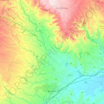
Name: Rosolini topographic map, elevation, terrain.
Location: Rosolini, Siracusa, Sicily, 96019, Italy (36.79834 14.83630 36.97595 14.97783)
Average elevation: 259 m
Minimum elevation: 14 m
Maximum elevation: 647 m
Other topographic maps
Click on a map to view its topography, its elevation and its terrain.
Palazzolo Acreide
Palazzolo Acreide, Siracusa, Sicily, 96010, Italy
Average elevation: 573 m
Carlentini
Italy > Sicily > Siracusa > Carlentini
Carlentini, Siracusa, Sicily, 96013, Italy
Average elevation: 188 m