
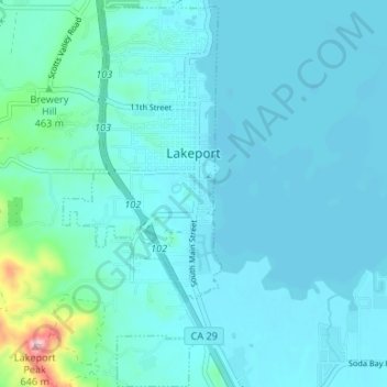
Lakeport topographic map
Interactive map
Click on the map to display elevation.
About this map
Name: Lakeport topographic map, elevation, terrain.
Average elevation: 427 m
Minimum elevation: 400 m
Maximum elevation: 656 m
Lakeport is an incorporated city and the county seat of Lake County, California. This city is 125 miles (201 km) northwest of Sacramento. Lakeport is on the western shore of the county namesake, Clear Lake, at an elevation of 1,355 feet (413 m). The population was 5,026 at the 2020 census, up from 4,753 at the 2010 census.
Other topographic maps
Click on a map to view its topography, its elevation and its terrain.
Lower Lake
United States > California > Lake County
Lower Lake, Lake County, California, 95457, United States
Average elevation: 490 m
Kelseyville
United States > California > Lake County
Kelseyville, Lake County, California, 95451, United States
Average elevation: 431 m
Clearlake
United States > California > Lake County
Clearlake, Lake County, California, United States
Average elevation: 474 m
Hidden Valley Lake
United States > California > Lake County
Hidden Valley Lake, Lake County, California, 95467, United States
Average elevation: 389 m
Clearlake
United States > California > Lake County > Clearlake > Clearlake
Clearlake, Lake County, California, 95422, United States
Average elevation: 467 m
Lakeport
United States > California > Lake County > Lakeport > Lakeport
Lakeport, Lake County, California, 95435, United States
Average elevation: 435 m