
East Ayton topographic map
Interactive map
Click on the map to display elevation.
About this map
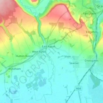
Name: East Ayton topographic map, elevation, terrain.
Average elevation: 65 m
Minimum elevation: 19 m
Maximum elevation: 201 m
Other topographic maps
Click on a map to view its topography, its elevation and its terrain.
Filey Brigg
United Kingdom > England > Scarborough
Filey Brigg, Savile's View, Gristhorpe, Scarborough, North Yorkshire, Yorkshire and the Humber, England, YO14 9PU, United Kingdom
Average elevation: 1 m
Goathland
United Kingdom > England > Scarborough > Goathland
Goathland, Scarborough, North Yorkshire, Yorkshire and the Humber, England, YO22 5LX, United Kingdom
Average elevation: 176 m
Hinderwell
United Kingdom > England > Scarborough > Hinderwell
Hinderwell, Scarborough, North Yorkshire, Yorkshire and the Humber, England, TS13 5JB, United Kingdom
Average elevation: 67 m
Cayton
United Kingdom > England > Scarborough > Cayton
Cayton, Scarborough, North Yorkshire, Yorkshire and the Humber, England, YO11 3RJ, United Kingdom
Average elevation: 40 m
Eskdaleside
United Kingdom > England > Scarborough > Eskdaleside
Eskdaleside, Scarborough, North Yorkshire, Yorkshire and the Humber, England, YO22 5EP, United Kingdom
Average elevation: 113 m
Muston
United Kingdom > England > Scarborough > Muston
Muston, Scarborough, North Yorkshire, Yorkshire and the Humber, England, YO14 0EP, United Kingdom
Average elevation: 51 m
Scalby
United Kingdom > England > Scarborough > Scalby
Scalby, Scarborough, North Yorkshire, Yorkshire and the Humber, England, YO13 0QJ, United Kingdom
Average elevation: 55 m
Beck Hole
United Kingdom > England > Scarborough
Beck Hole, Scarborough, North Yorkshire, Yorkshire and the Humber, England, YO11 3PF, United Kingdom
Average elevation: 40 m
Hackness
United Kingdom > England > Scarborough
Hackness, Scarborough, North Yorkshire, Yorkshire and the Humber, England, United Kingdom
Average elevation: 116 m
Little Fryup Beck
United Kingdom > England > Scarborough
Little Fryup Beck, Scarborough, North Yorkshire, Yorkshire and the Humber, England, YO21 2NS, United Kingdom
Average elevation: 234 m
Star Carr
United Kingdom > England > Scarborough
Star Carr, Metes Lane, Seamer, Scarborough, North Yorkshire, Yorkshire and the Humber, England, YO12 4PZ, United Kingdom
Average elevation: 28 m
Sneaton
United Kingdom > England > Scarborough
Sneaton, Scarborough, North Yorkshire, Yorkshire and the Humber, England, United Kingdom
Average elevation: 162 m
Reighton
United Kingdom > England > Scarborough
Reighton, Scarborough, North Yorkshire, Yorkshire and the Humber, England, United Kingdom
Average elevation: 71 m
Wykeham
United Kingdom > England > Scarborough
Wykeham, Scarborough, North Yorkshire, Yorkshire and the Humber, England, United Kingdom
Average elevation: 86 m
Burniston
United Kingdom > England > Scarborough
Burniston, Scarborough, North Yorkshire, Yorkshire and the Humber, England, United Kingdom
Average elevation: 54 m