
Ripponden topographic map
Interactive map
Click on the map to display elevation.
About this map
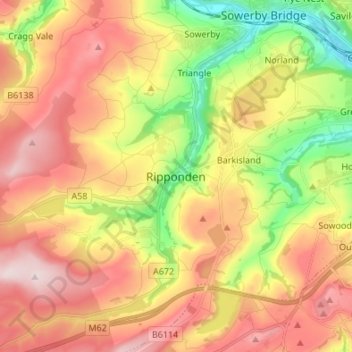
Name: Ripponden topographic map, elevation, terrain.
Average elevation: 259 m
Minimum elevation: 69 m
Maximum elevation: 434 m
Other topographic maps
Click on a map to view its topography, its elevation and its terrain.
Ringstone Edge Moor
United Kingdom > England > Calderdale > Ripponden
Ringstone Edge Moor, Ripponden, Calderdale, West Yorkshire, Yorkshire and the Humber, England, HX6, United Kingdom
Average elevation: 243 m