
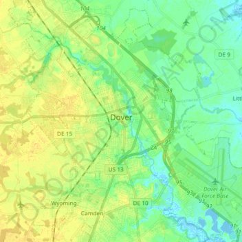
Dover topographic map
Interactive map
Click on the map to display elevation.
About this map
Name: Dover topographic map, elevation, terrain.
Location: Dover, Kent County, Delaware, United States (39.10220 -75.58620 39.21025 -75.44073)
Average elevation: 10 m
Minimum elevation: -5 m
Maximum elevation: 19 m
Other topographic maps
Click on a map to view its topography, its elevation and its terrain.
Camden
United States > Delaware > Kent County
Camden, Kent County, Delaware, United States
Average elevation: 13 m
Holletts Corners
United States > Delaware > Kent County
Holletts Corners, Kent County, Delaware, United States
Average elevation: 21 m
Woodstock Court
United States > Delaware > Kent County > Dover
Woodstock Court, Dover, Kent County, Delaware, 19904, United States
Average elevation: 13 m
Lake Bernard
United States > Delaware > Kent County > Florence
Lake Bernard, Florence, Kent County, Delaware, United States
Average elevation: 4 m
Marydel
United States > Delaware > Kent County
Marydel, Kent County, Delaware, 19964, United States
Average elevation: 19 m
Cheswold
United States > Delaware > Kent County
Cheswold, Kent County, Delaware, 19936, United States
Average elevation: 13 m
Harrington
United States > Delaware > Kent County
Harrington, Kent County, Delaware, United States
Average elevation: 17 m
Cheswold
United States > Delaware > Kent County > Cheswold
Cheswold, Kent County, Delaware, 19936, United States
Average elevation: 13 m
Tidbury Manor
United States > Delaware > Kent County > Tidbury Manor
Tidbury Manor, Kent County, Delaware, 19901:19962, United States
Average elevation: 8 m
Felton
United States > Delaware > Kent County
Felton, Kent County, Delaware, United States
Average elevation: 18 m