
Dead Vlei topographic map
Interactive map
Click on the map to display elevation.
About this map
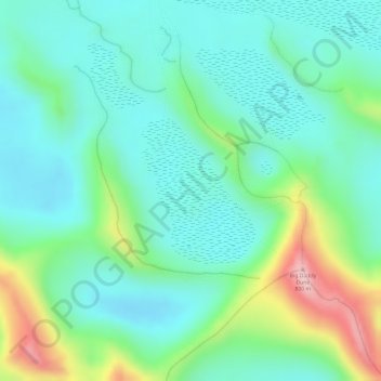
Name: Dead Vlei topographic map, elevation, terrain.
Location: Dead Vlei, Big Daddy Hiking Trail, Hardap, Namibia (-24.76810 15.29037 -24.75774 15.29940)
Average elevation: 613 m
Minimum elevation: 537 m
Maximum elevation: 804 m
Other topographic maps
Click on a map to view its topography, its elevation and its terrain.
Namib-Naukluft National Park
Namib-Naukluft National Park, Hardap, Namibia
Average elevation: 631 m
NamibRand Nature Reserve
NamibRand Nature Reserve, Hardap, Namibia
Average elevation: 1,160 m