
Kelso topographic map
Interactive map
Click on the map to display elevation.
About this map
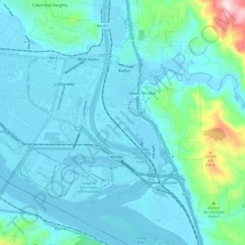
Name: Kelso topographic map, elevation, terrain.
Location: Kelso, Cowlitz County, Washington, 98626, United States (46.08335 -122.92391 46.16592 -122.85526)
Average elevation: 52 m
Minimum elevation: -5 m
Maximum elevation: 410 m
Other topographic maps
Click on a map to view its topography, its elevation and its terrain.
Ryderwood
United States > Washington > Cowlitz County
Ryderwood, Cowlitz County, Washington, 98581, United States
Average elevation: 158 m
Toutle River Sediment Retention Structure
United States > Washington > Cowlitz County
Toutle River Sediment Retention Structure, Cowlitz County, Washington, United States
Average elevation: 347 m
Kalama
United States > Washington > Cowlitz County
Kalama, Cowlitz County, Washington, 98625, United States
Average elevation: 58 m
Ariel
United States > Washington > Cowlitz County
Ariel, Cowlitz County, Washington, United States
Average elevation: 206 m
Woodland
United States > Washington > Cowlitz County
Woodland, Cowlitz County, Washington, 98674, United States
Average elevation: 36 m
Yale
United States > Washington > Cowlitz County
Yale, Cowlitz County, Washington, 98603, United States
Average elevation: 257 m
Castle Rock
United States > Washington > Cowlitz County
Castle Rock, Cowlitz County, Washington, 98611, United States
Average elevation: 55 m
Cougar
United States > Washington > Cowlitz County
Cougar, Cowlitz County, Washington, 98616, United States
Average elevation: 311 m