
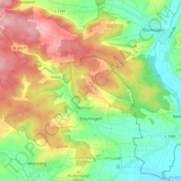
Zöschingen topographic map
Interactive map
Click on the map to display elevation.
About this map
Name: Zöschingen topographic map, elevation, terrain.
Average elevation: 524 m
Minimum elevation: 453 m
Maximum elevation: 616 m
Other topographic maps
Click on a map to view its topography, its elevation and its terrain.
Bachhagel
Germany > Bavaria > Landkreis Dillingen an der Donau
Bachhagel, Syrgenstein (VGem), Landkreis Dillingen an der Donau, Bavaria, 89429, Germany
Average elevation: 488 m
Lauingen (Donau)
Germany > Bavaria > Landkreis Dillingen an der Donau
Lauingen (Donau), Landkreis Dillingen an der Donau, Bavaria, 89415, Germany
Average elevation: 434 m
Hettlingen
Germany > Bavaria > Landkreis Dillingen an der Donau > Wertingen
Hettlingen, Wertingen, Landkreis Dillingen an der Donau, Bavaria, 86637, Germany
Average elevation: 446 m