
Putre topographic map
Interactive map
Click on the map to display elevation.
About this map
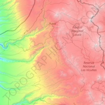
Name: Putre topographic map, elevation, terrain.
Average elevation: 3,263 m
Minimum elevation: 449 m
Maximum elevation: 6,299 m
Putre is a Chilean town and commune, capital of the Parinacota Province in the Arica-Parinacota Region. It is located 130 km (81 mi) east of Arica, at an altitude of 3,500 m (11,483 ft). The town is backdropped by Taapaca volcanic complex.
Other topographic maps
Click on a map to view its topography, its elevation and its terrain.
Volcán Parinacota
Chile > Arica and Parinacota Region > Provincia de Parinacota > Putre
Volcán Parinacota, Putre, Provincia de Parinacota, Arica and Parinacota Region, Chile
Average elevation: 5,808 m