
Burns Lake topographic map
Interactive map
Click on the map to display elevation.
About this map
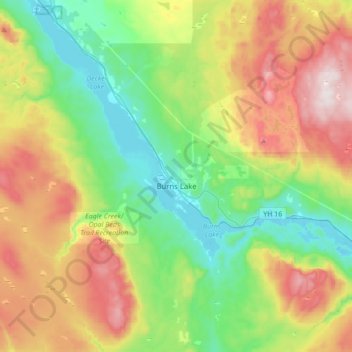
Name: Burns Lake topographic map, elevation, terrain.
Average elevation: 942 m
Minimum elevation: 695 m
Maximum elevation: 1,374 m
Other topographic maps
Click on a map to view its topography, its elevation and its terrain.
Vanderhoof
Canada > Colombie-Britannique > district régionel de Bulkley-Néchako
Vanderhoof, district régionel de Bulkley-Néchako, Colombie-Britannique, Canada
Average elevation: 739 m