
Awutu Bereku topographic map
Interactive map
Click on the map to display elevation.
About this map
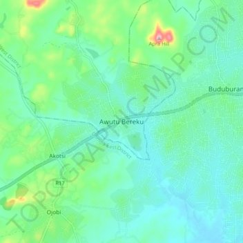
Name: Awutu Bereku topographic map, elevation, terrain.
Location: Awutu Bereku, Awutu Senya West District, Central Region, Ghana (5.47265 -0.55266 5.55265 -0.47266)
Average elevation: 57 m
Minimum elevation: 16 m
Maximum elevation: 207 m
Other topographic maps
Click on a map to view its topography, its elevation and its terrain.
Awutu Breku
Ghana > Central Region > Awutu Senya West District
Awutu Breku, Awutu Senya West District, Central Region, Ghana
Average elevation: 103 m