
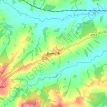
Burwash topographic map
Interactive map
Click on the map to display elevation.
About this map
Name: Burwash topographic map, elevation, terrain.
Average elevation: 56 m
Minimum elevation: 19 m
Maximum elevation: 130 m
Other topographic maps
Click on a map to view its topography, its elevation and its terrain.
Guestling
United Kingdom > England > East Sussex > Rother District
Guestling, Rother District, East Sussex, England, United Kingdom
Average elevation: 39 m
Whydown
United Kingdom > England > East Sussex > Rother District
Whydown, Bexhill-on-Sea, Rother District, East Sussex, England, TN39 4RB, United Kingdom
Average elevation: 24 m
Dallington
United Kingdom > England > East Sussex > Rother District > Dallington
Dallington, Rother District, East Sussex, South East England, England, United Kingdom
Average elevation: 109 m
Fairlight
United Kingdom > England > East Sussex > Rother District
Fairlight, Rother District, East Sussex, England, United Kingdom
Average elevation: 47 m
Winchelsea Beach
United Kingdom > England > East Sussex > Rother District
Winchelsea Beach, Rother District, East Sussex, England, TN36 4NA, United Kingdom
Average elevation: 3 m