
Kungsholmen topographic map
Interactive map
Click on the map to display elevation.
About this map
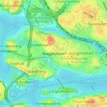
Name: Kungsholmen topographic map, elevation, terrain.
Average elevation: 18 m
Minimum elevation: -1 m
Maximum elevation: 54 m
Other topographic maps
Click on a map to view its topography, its elevation and its terrain.
Södermalm
Suecia > Provincia de Estocolmo > Estocolmo
Södermalm, Estocolmo, Provincia de Estocolmo, Svealand, Suecia
Average elevation: 22 m