
Amherst topographic map
Interactive map
Click on the map to display elevation.
About this map
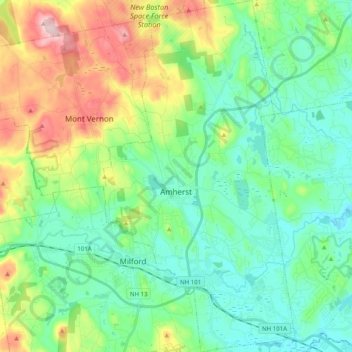
Name: Amherst topographic map, elevation, terrain.
Average elevation: 127 m
Minimum elevation: 50 m
Maximum elevation: 320 m
According to the United States Census Bureau, the town has a total area of 34.7 square miles (89.9 km2), of which 34.2 square miles (88.5 km2) is land and 0.54 square miles (1.4 km2), or 1.51% of the total area, is water. Located on the Souhegan River, Amherst is drained by Beaver, Bloody, and Joe English brooks. Amherst's highest point is on Chestnut Hill at the town's northern border, where the elevation reaches 865 feet (264 m) above sea level. Amherst lies fully within the Merrimack River watershed.