
Görlitz topographic map
Interactive map
Click on the map to display elevation.
About this map
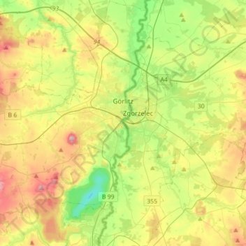
Name: Görlitz topographic map, elevation, terrain.
Location: Görlitz, Saxony, Germany (51.05256 14.91168 51.22796 15.01794)
Average elevation: 223 m
Minimum elevation: 102 m
Maximum elevation: 401 m
Other topographic maps
Click on a map to view its topography, its elevation and its terrain.
Schlauroth
Germany > Saxony > Görlitz > Görlitz
Schlauroth, Görlitz, Saxony, 02827, Germany
Average elevation: 240 m
Neusalza-Spremberg
Germany > Saxony > Görlitz > Neusalza-Spremberg > Sonneberg
Neusalza-Spremberg, Sonneberg, Neusalza-Spremberg, Görlitz, Saxony, 02742, Germany
Average elevation: 355 m
Bruder Klaus
Germany > Saxony > Görlitz > Jonsdorf
Bruder Klaus, Jonsdorf, Olbersdorf, Görlitz, Saxony, 02796, Germany
Average elevation: 523 m