
Magog topographic map
Interactive map
Click on the map to display elevation.
About this map
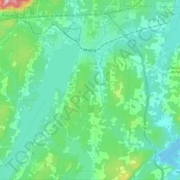
Name: Magog topographic map, elevation, terrain.
Location: Magog, Memphrémagog, Estrie, Quebec, Canada (45.16080 -72.24729 45.30571 -72.04219)
Average elevation: 250 m
Minimum elevation: 159 m
Maximum elevation: 674 m
Other topographic maps
Click on a map to view its topography, its elevation and its terrain.
Mansonville
Canada > Quebec > Memphrémagog > Potton
Mansonville, Potton, Memphrémagog, Estrie, Quebec, J0E 1X0, Canada
Average elevation: 211 m
Potton
Canada > Quebec > Memphrémagog
Potton, Memphrémagog, Estrie, Quebec, J0E 1X0, Canada
Average elevation: 321 m
Hatley
Canada > Quebec > Memphrémagog > Hatley
Hatley, Memphrémagog, Estrie, Quebec, Canada
Average elevation: 294 m