
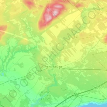
Pont-Rouge topographic map
Interactive map
Click on the map to display elevation.
About this map
Name: Pont-Rouge topographic map, elevation, terrain.
Average elevation: 117 m
Minimum elevation: -1 m
Maximum elevation: 356 m
Other topographic maps
Click on a map to view its topography, its elevation and its terrain.
Saint-Casimir
Canada > Quebec > Portneuf (MRC)
Saint-Casimir, Portneuf (MRC), Capitale-Nationale, Quebec, G0A 3L0, Canada
Average elevation: 49 m
Saint-Gilbert
Canada > Quebec > Portneuf (MRC)
Saint-Gilbert, Portneuf (MRC), Capitale-Nationale, Quebec, Canada
Average elevation: 86 m