
Agadir topographic map
Interactive map
Click on the map to display elevation.
About this map
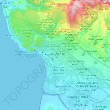
Name: Agadir topographic map, elevation, terrain.
Average elevation: 153 m
Minimum elevation: -2 m
Maximum elevation: 821 m
Other topographic maps
Click on a map to view its topography, its elevation and its terrain.
Agadir
Morocco > Pachalik d'Agadir ⵍⴱⴰⵛⴰⵡⵉⵢⴰ ⵏ ⴰⴳⴰⴷⵉⵔ باشوية أكادير
Agadir, Pachalik d'Agadir ⵍⴱⴰⵛⴰⵡⵉⵢⴰ ⵏ ⴰⴳⴰⴷⵉⵔ باشوية أكادير, Agadir Ida-Outanane Prefecture, Souss-Massa, 80025, Morocco
Average elevation: 166 m