
Río Grande topographic map
Interactive map
Click on the map to display elevation.
About this map
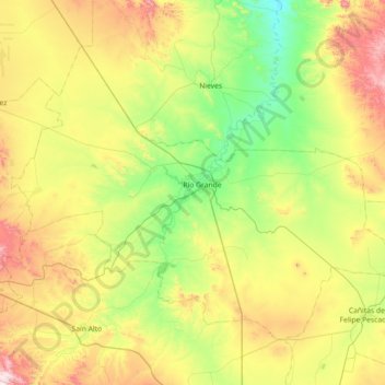
Name: Río Grande topographic map, elevation, terrain.
Location: Río Grande, Zacatecas, 98400, Mexico (23.55942 -103.39197 24.06550 -102.67373)
Average elevation: 2,059 m
Minimum elevation: 1,748 m
Maximum elevation: 2,663 m
Over 96% of the municipality's area lies in the drainage basin of the Aguanaval River, the main watercourse in the area which flows south to north through the municipality. This river was known as the Río Grande in the 16th and 17th centuries despite its modest size. The highest point in the municipality is the Cerro Tetilla Grande located at 23°41′N 102°51′W / 23.683°N 102.850°W / 23.683; -102.850 with an elevation of 2,370 metres (7,780 ft) above sea level.
Other topographic maps
Click on a map to view its topography, its elevation and its terrain.
Pozo Hondo
Mexico > Zacatecas > Villa de Cos
Pozo Hondo, Villa de Cos, Zacatecas, Mexico
Average elevation: 2,032 m