
Querétaro topographic map
Interactive map
Click on the map to display elevation.
About this map
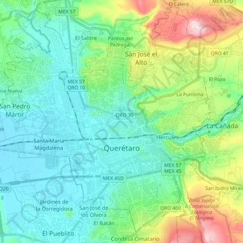
Name: Querétaro topographic map, elevation, terrain.
Location: Querétaro, Municipio de Querétaro, Querétaro, Mexico (20.54031 -100.48015 20.68397 -100.31196)
Average elevation: 1,921 m
Minimum elevation: 1,795 m
Maximum elevation: 2,316 m
The municipality has rolling hills, mountain ranges and flatlands. Most of the rolling hills cross the territory from south to north, paralleling the Querétaro-San Luis Potosí highway. Most plains are located in the north, and are of sedimentary soil with some protrusions of volcanic rock. Altitude varies from 1,900 to 2,460 meters above sea level with the highest elevations at mountains called El Buey, Pie de Gallo, El Patol, El Nabo, and El Paisano. The city proper is on a plain at 1,900 meters. There is only one river, the Querétaro River, which carved the La Cañada. There are numerous streams, many of them seasonal, and fresh water springs near the mountain areas. The climate is temperate and semi-dry in which the summers can be hot, with high up to 36C in May and June. Freezing temperatures are possible in the winter.
Other topographic maps
Click on a map to view its topography, its elevation and its terrain.
El Nabo
Mexico > Querétaro > Municipio de Querétaro
El Nabo, Municipio de Querétaro, Querétaro, 76230, Mexico
Average elevation: 1,924 m
La Versolilla
Mexico > Querétaro > Municipio de Querétaro
La Versolilla, Municipio de Querétaro, Querétaro, Mexico
Average elevation: 2,227 m
Santa Catarina
Mexico > Querétaro > Municipio de Querétaro
Santa Catarina, Municipio de Querétaro, Querétaro, 76220, Mexico
Average elevation: 2,008 m
Pintillo
Mexico > Querétaro > Municipio de Querétaro
Pintillo, Municipio de Querétaro, Querétaro, 76220, Mexico
Average elevation: 2,033 m
La Estacada
Mexico > Querétaro > Municipio de Querétaro
La Estacada, Municipio de Querétaro, Querétaro, 67230, Mexico
Average elevation: 2,086 m
La Luz
Mexico > Querétaro > Municipio de Querétaro
La Luz, Municipio de Querétaro, Querétaro, 67230, Mexico
Average elevation: 2,120 m
Santa Rosa Jauregui
Mexico > Querétaro > Municipio de Querétaro
Santa Rosa Jauregui, Municipio de Querétaro, Querétaro, Mexico
Average elevation: 1,979 m
Juriquilla
Mexico > Querétaro > Municipio de Querétaro > Juriquilla
Juriquilla, Municipio de Querétaro, Querétaro, Mexico
Average elevation: 1,924 m
Don manuel
Mexico > Querétaro > Municipio de Querétaro > Querétaro
Don manuel, Huertas Don Manuel, Delegación Félix Osores, Querétaro, Municipio de Querétaro, Querétaro, 76113, Mexico
Average elevation: 1,810 m