
Santa Clara Coatitla topographic map
Interactive map
Click on the map to display elevation.
About this map
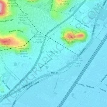
Name: Santa Clara Coatitla topographic map, elevation, terrain.
Location: Santa Clara Coatitla, Ecatepec de Morelos, 55540, México (19.52075 -99.08828 19.56075 -99.04828)
Average elevation: 2,263 m
Minimum elevation: 2,230 m
Maximum elevation: 2,501 m
Other topographic maps
Click on a map to view its topography, its elevation and its terrain.
Santa María Tulpetlac
Santa María Tulpetlac, Ecatepec de Morelos, 55400, México
Average elevation: 2,280 m
San Andrés de la Cañada
San Andrés de la Cañada, Ecatepec de Morelos, 55519, México
Average elevation: 2,500 m