
Deggendorf topographic map
Interactive map
Click on the map to display elevation.
About this map
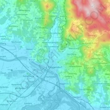
Name: Deggendorf topographic map, elevation, terrain.
Location: Deggendorf, Landkreis Deggendorf, Bavaria, 94469, Germany (48.78686 12.87356 48.90861 13.07415)
Average elevation: 449 m
Minimum elevation: 309 m
Maximum elevation: 1,101 m
Other topographic maps
Click on a map to view its topography, its elevation and its terrain.
Neuhausen
Germany > Bavaria > Landkreis Deggendorf
Neuhausen, Offenberg, Landkreis Deggendorf, Bavaria, 94560, Germany
Average elevation: 341 m
Otzing
Germany > Bavaria > Landkreis Deggendorf
Otzing, Oberpöring (VGem), Landkreis Deggendorf, Bavaria, 94563, Germany
Average elevation: 328 m
Schuhreith
Germany > Bavaria > Landkreis Deggendorf > Mimming
Schuhreith, Mimming, Hengersberg, Landkreis Deggendorf, Bavaria, 94491, Germany
Average elevation: 337 m
Plattling
Germany > Bavaria > Landkreis Deggendorf
Plattling, Landkreis Deggendorf, Bavaria, 94447, Germany
Average elevation: 321 m
Dobl
Germany > Bavaria > Landkreis Deggendorf
Dobl, Winzer, Landkreis Deggendorf, Bavaria, 94547, Germany
Average elevation: 378 m