
Aue topographic map
Interactive map
Click on the map to display elevation.
About this map
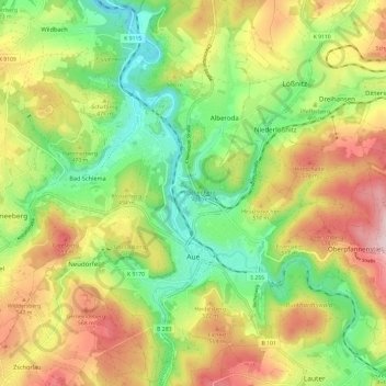
Name: Aue topographic map, elevation, terrain.
Location: Aue, Aue-Bad Schlema, Erzgebirgskreis, Saxony, 08280, Germany (50.56151 12.65549 50.63743 12.73984)
Average elevation: 465 m
Minimum elevation: 315 m
Maximum elevation: 657 m
Other topographic maps
Click on a map to view its topography, its elevation and its terrain.
Ehrenfriedersdorf
Germany > Saxony > Erzgebirgskreis
Ehrenfriedersdorf, Erzgebirgskreis, Saxony, 09427, Germany
Average elevation: 582 m
Tannenberg
Germany > Saxony > Erzgebirgskreis
Tannenberg, Verwaltungsgemeinschaft Geyer, Erzgebirgskreis, Saxony, Germany
Average elevation: 590 m
Olbernhau
Germany > Saxony > Erzgebirgskreis
Olbernhau, Erzgebirgskreis, Saxony, 09526, Germany
Average elevation: 612 m
Niederdorf
Germany > Saxony > Erzgebirgskreis
Niederdorf, Stollberg/Erzgeb., Erzgebirgskreis, Saxony, Germany
Average elevation: 413 m
Kühnhaide
Germany > Saxony > Erzgebirgskreis > Marienberg > Kühnhaide
Kühnhaide, Marienberg, Erzgebirgskreis, Saxony, 09496, Germany
Average elevation: 760 m
Andreasberg
Germany > Saxony > Erzgebirgskreis > Auerbach
Andreasberg, Auerbach, Burkhardtsdorf, Erzgebirgskreis, Saxony, 09390, Germany
Average elevation: 546 m
Oberwiesenthal
Germany > Saxony > Erzgebirgskreis
Oberwiesenthal, Erzgebirgskreis, Saxony, 09484, Germany
Average elevation: 928 m