
Olpe topographic map
Interactive map
Click on the map to display elevation.
About this map
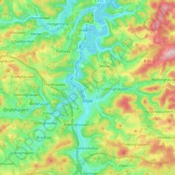
Name: Olpe topographic map, elevation, terrain.
Location: Olpe, Kreis Olpe, North Rhine-Westphalia, 57462, Germany (50.98703 7.80409 51.08780 7.97420)
Average elevation: 400 m
Minimum elevation: 306 m
Maximum elevation: 581 m
Other topographic maps
Click on a map to view its topography, its elevation and its terrain.
Rüblinghausen
Germany > North Rhine-Westphalia > Kreis Olpe > Olpe > Rüblinghausen
Rüblinghausen, Olpe, Kreis Olpe, North Rhine-Westphalia, 57462, Germany
Average elevation: 371 m