
Suhl topographic map
Interactive map
Click on the map to display elevation.
About this map
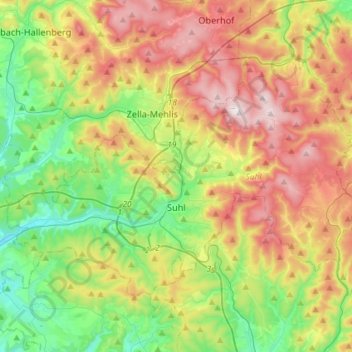
Name: Suhl topographic map, elevation, terrain.
Location: Suhl, Thuringia, Germany (50.56075 10.55215 50.68895 10.84262)
Average elevation: 602 m
Minimum elevation: 342 m
Maximum elevation: 979 m
Suhl is located on the south-western edge of the Thuringian Forest. To the south-west, the Small Thuringian Forest (some foothills of the Thuringian forest) is situated. The terrain is mountainous to all directions, some important mountains are: the Großer Beerberg (983 m, highest one in Thuringia) in the north-east, the Ringberg (745 m), the Döllberg (760 m), the Friedberg (649 m) and the Adlersberg (859 m) in the east, the Steinsburg (641 m) in the south, the Heiliger Berg (513 m), the Domberg (675 m) and the Berg Bock (709 m) in the north-west as well as the Bocksberg (609 m) and the Hoheloh (526 m) within the city. The centre itself is located in an elevation of 450 m and nearly the complete non-build on part of the municipal territory is forested. There are a few small rivers running through Suhl: The Hasel rises at Friedberg in the south-east and runs westward through Suhl, Heinrichs, Mäbendorf, Dietzhausen and Wichtshausen. The Lauter rises on the southern slope of Großer Beerberg mountain and runs through Goldlauter, Lauter and the city centre, before it joins the Hasel behind the station. The Mühlwasser rises on the western slope of Großer Beerberg and runs southward through the northern city parts before it joins the Lauter at the northern city centre.
Other topographic maps
Click on a map to view its topography, its elevation and its terrain.
Großbreitenbach
Germany > Thuringia > Ilm-Kreis > Großbreitenbach
Großbreitenbach, Ilm-Kreis, Thuringia, Germany
Average elevation: 596 m
Langenroda
Germany > Thuringia > Kyffhäuserkreis
Langenroda, Wiehe, Roßleben-Wiehe, Kyffhäuserkreis, Thuringia, Germany
Average elevation: 236 m
Kella
Germany > Thuringia > Landkreis Eichsfeld
Kella, Ershausen/Geismar, Landkreis Eichsfeld, Thuringia, Germany
Average elevation: 361 m
Ramsberg
Germany > Thuringia > Wartburgkreis > Lauterbach
Ramsberg, Lauterbach, Hainich-Werratal, Wartburgkreis, Thuringia, 99826, Germany
Average elevation: 324 m
Schleusingen
Germany > Thuringia > Landkreis Hildburghausen
Schleusingen, Landkreis Hildburghausen, Thuringia, 98553, Germany
Average elevation: 459 m
Artern
Germany > Thuringia > Kyffhäuserkreis
Artern, Kyffhäuserkreis, Thuringia, 06556, Germany
Average elevation: 131 m
Schwabhausen
Germany > Thuringia > Landkreis Gotha
Schwabhausen, Drei Gleichen, Landkreis Gotha, Thuringia, Germany
Average elevation: 352 m
Ichstedt
Germany > Thuringia > Kyffhäuserkreis > Bad Frankenhausen/Kyffhäuser
Ichstedt, Bad Frankenhausen/Kyffhäuser, Kyffhäuserkreis, Thuringia, Germany
Average elevation: 175 m
Mühlhausen
Germany > Thuringia > Unstrut-Hainich-Kreis
Mühlhausen, Unstrut-Hainich-Kreis, Thuringia, Germany
Average elevation: 288 m
Rotterode
Germany > Thuringia > Landkreis Schmalkalden-Meiningen > Steinbach-Hallenberg
Rotterode, Steinbach-Hallenberg, Landkreis Schmalkalden-Meiningen, Thuringia, 98587, Germany
Average elevation: 570 m
Steinach
Germany > Thuringia > Landkreis Sonneberg
Steinach, Landkreis Sonneberg, Thuringia, 96523, Germany
Average elevation: 653 m
Bad Salzungen
Germany > Thuringia > Wartburgkreis
Bad Salzungen, Wartburgkreis, Thuringia, Germany
Average elevation: 347 m
Leinefelde
Germany > Thuringia > Landkreis Eichsfeld > Leinefelde-Worbis
Leinefelde, Leinefelde-Worbis, Landkreis Eichsfeld, Thuringia, 37327, Germany
Average elevation: 360 m
Zeulenroda
Zeulenroda, Zeulenroda-Triebes, Greiz, Thuringia, 07937, Germany
Average elevation: 406 m
Birkenfeld
Germany > Thuringia > Landkreis Hildburghausen > Hildburghausen
Birkenfeld, Hildburghausen, Landkreis Hildburghausen, Thuringia, 98669, Germany
Average elevation: 418 m
Sondershausen
Germany > Thuringia > Kyffhäuserkreis
Sondershausen, Kyffhäuserland, Kyffhäuserkreis, Thuringia, 99707, Germany
Average elevation: 273 m
Eisenberg
Germany > Thuringia > Saale-Holzland-Kreis
Eisenberg, Saale-Holzland-Kreis, Thuringia, 07607, Germany
Average elevation: 305 m
Schleiz
Germany > Thuringia > Saale-Orla-Kreis
Schleiz, Saale-Orla-Kreis, Thuringia, 07907, Germany
Average elevation: 479 m
Zschernitzsch
Germany > Thuringia > Altenburger Land > Schmölln
Zschernitzsch, Schmölln, Altenburger Land, Thuringia, 04626, Germany
Average elevation: 241 m
Sömmerda
Germany > Thuringia > Landkreis Sömmerda
Sömmerda, Landkreis Sömmerda, Thuringia, 99610, Germany
Average elevation: 155 m
Gerstungen
Germany > Thuringia > Wartburgkreis
Gerstungen, Wartburgkreis, Thuringia, 99834, Germany
Average elevation: 302 m
Roßdorf
Germany > Thuringia > Landkreis Schmalkalden-Meiningen
Roßdorf, Breitungen/Werra, Landkreis Schmalkalden-Meiningen, Thuringia, Germany
Average elevation: 436 m
Hermsdorf
Germany > Thuringia > Saale-Holzland-Kreis
Hermsdorf, Saale-Holzland-Kreis, Thuringia, Germany
Average elevation: 339 m
Bad Liebenstein
Germany > Thuringia > Wartburgkreis
Bad Liebenstein, Wartburgkreis, Thuringia, Germany
Average elevation: 424 m
Meiningen
Germany > Thuringia > Landkreis Schmalkalden-Meiningen > Meiningen
Meiningen, Kernstadt Meiningen, Meiningen, Landkreis Schmalkalden-Meiningen, Thuringia, 98617, Germany
Average elevation: 394 m
Breitungen/Werra
Germany > Thuringia > Landkreis Schmalkalden-Meiningen
Breitungen/Werra, Landkreis Schmalkalden-Meiningen, Thuringia, Germany
Average elevation: 345 m
Ohrdruf
Germany > Thuringia > Landkreis Gotha
Ohrdruf, Landkreis Gotha, Thuringia, 99885, Germany
Average elevation: 518 m
Rudersdorf
Germany > Thuringia > Landkreis Sömmerda
Rudersdorf, Buttstädt, Landkreis Sömmerda, Thuringia, Germany
Average elevation: 206 m
Höngeda
Germany > Thuringia > Unstrut-Hainich-Kreis > Mühlhausen
Höngeda, Mühlhausen, Unstrut-Hainich-Kreis, Thuringia, 99998, Germany
Average elevation: 202 m
Dietzenrode/Vatterode
Germany > Thuringia > Landkreis Eichsfeld
Dietzenrode/Vatterode, Uder, Landkreis Eichsfeld, Thuringia, Germany
Average elevation: 302 m
Zeutsch
Germany > Thuringia > Landkreis Saalfeld-Rudolstadt > Uhlstädt-Kirchhasel
Zeutsch, Uhlstädt-Kirchhasel, Landkreis Saalfeld-Rudolstadt, Thuringia, Germany
Average elevation: 227 m
Voigtstedt
Germany > Thuringia > Kyffhäuserkreis > Artern
Voigtstedt, Artern, Kyffhäuserkreis, Thuringia, Germany
Average elevation: 134 m
Burgtonna
Germany > Thuringia > Landkreis Gotha
Burgtonna, Tonna, Fahner Höhe, Landkreis Gotha, Thuringia, 99958, Germany
Average elevation: 234 m
Tanna
Germany > Thuringia > Saale-Orla-Kreis
Tanna, Saale-Orla-Kreis, Thuringia, 07922, Germany
Average elevation: 556 m
Hopfgarten
Germany > Thuringia > Landkreis Weimarer Land
Hopfgarten, Grammetal, Landkreis Weimarer Land, Thuringia, Germany
Average elevation: 282 m
Walkes
Germany > Thuringia > Wartburgkreis > Geisa
Walkes, Geisa, Wartburgkreis, Thuringia, Germany
Average elevation: 487 m
Unstrut-Hainich
Germany > Thuringia > Unstrut-Hainich-Kreis > Unstrut-Hainich
Unstrut-Hainich, Unstrut-Hainich-Kreis, Thuringia, 99991, Germany
Average elevation: 279 m
Burg Ehrenstein
Germany > Thuringia > Ilm-Kreis > Stadtilm > Ehrenstein
Burg Ehrenstein, Ehrenstein, Stadtilm, Ilm-Kreis, Thuringia, 99326, Germany
Average elevation: 415 m
Rodeberg
Germany > Thuringia > Unstrut-Hainich-Kreis > Rodeberg
Rodeberg, Südeichsfeld, Unstrut-Hainich-Kreis, Thuringia, Germany
Average elevation: 422 m
Thamsbrück
Germany > Thuringia > Unstrut-Hainich-Kreis > Bad Langensalza > Thamsbrück
Thamsbrück, Bad Langensalza, Unstrut-Hainich-Kreis, Thuringia, 99947, Germany
Average elevation: 189 m
Tonna
Germany > Thuringia > Landkreis Gotha
Tonna, Fahner Höhe, Landkreis Gotha, Thuringia, 99958, Germany
Average elevation: 228 m
Ferna
Germany > Thuringia > Landkreis Eichsfeld
Ferna, Lindenberg/Eichsfeld, Landkreis Eichsfeld, Thuringia, Germany
Average elevation: 294 m
Nordhausen
Germany > Thuringia > Landkreis Nordhausen
Nordhausen, Landkreis Nordhausen, Thuringia, 99734, Germany
Average elevation: 246 m