
Datteln topographic map
Interactive map
Click on the map to display elevation.
About this map
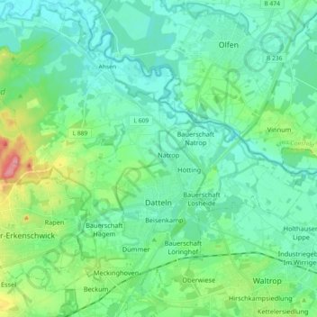
Name: Datteln topographic map, elevation, terrain.
Average elevation: 61 m
Minimum elevation: 36 m
Maximum elevation: 154 m
Other topographic maps
Click on a map to view its topography, its elevation and its terrain.
Gladbeck
Germany > North Rhine-Westphalia > Kreis Recklinghausen
Gladbeck, Kreis Recklinghausen, North Rhine-Westphalia, Germany
Average elevation: 55 m
Lembeck
Germany > North Rhine-Westphalia > Kreis Recklinghausen > Dorsten
Lembeck, Dorsten, Kreis Recklinghausen, North Rhine-Westphalia, 46286, Germany
Average elevation: 67 m
Recklinghausen
Germany > North Rhine-Westphalia > Kreis Recklinghausen
Recklinghausen, Kreis Recklinghausen, North Rhine-Westphalia, Germany
Average elevation: 70 m