
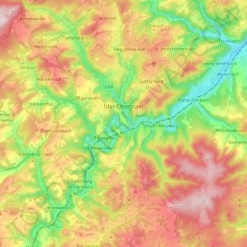
Idar-Oberstein topographic map
Interactive map
Click on the map to display elevation.
About this map
Name: Idar-Oberstein topographic map, elevation, terrain.
Average elevation: 406 m
Minimum elevation: 210 m
Maximum elevation: 617 m
Idar-Oberstein/Göttschied Airfield lies north of the town between the constituent community of Göttschied and the municipalities of Gerach and Hintertiefenbach at an elevation of 480 m above sea level (1,575 feet). Its ICAO location indicator is EDRG. The grass landing strip's orientation is 06/24, and it is 650 m long and 50 m wide. The allowable landing weight is 2 000 kg; however, with PPR (“prior permission required”), aircraft of up to 3 700 kg may land. The airport is designed for helicopters, motor gliders, gliders, ultralights and, also with PPR, skydivers.
Other topographic maps
Click on a map to view its topography, its elevation and its terrain.
Mittelreidenbach
Germany > Rhineland-Palatinate > Landkreis Birkenfeld
Mittelreidenbach, Herrstein-Rhaunen, Landkreis Birkenfeld, Rhineland-Palatinate, Germany
Average elevation: 340 m
Hallenbad Idar-Oberstein
Germany > Rhineland-Palatinate > Landkreis Birkenfeld > Idar-Oberstein
Hallenbad Idar-Oberstein, 213, Hauptstraße, Idar, Idar-Oberstein, Landkreis Birkenfeld, Rhineland-Palatinate, 55743, Germany
Average elevation: 343 m
Baumholder
Germany > Rhineland-Palatinate > Landkreis Birkenfeld
Baumholder, Landkreis Birkenfeld, Rhineland-Palatinate, 55774, Germany
Average elevation: 451 m
Heimbach
Germany > Rhineland-Palatinate > Landkreis Birkenfeld
Heimbach, Baumholder, Landkreis Birkenfeld, Rhineland-Palatinate, Germany
Average elevation: 412 m
Gollenberg
Germany > Rhineland-Palatinate > Landkreis Birkenfeld
Gollenberg, Birkenfeld, Landkreis Birkenfeld, Rhineland-Palatinate, Germany
Average elevation: 466 m