
Hildesheim topographic map
Interactive map
Click on the map to display elevation.
About this map
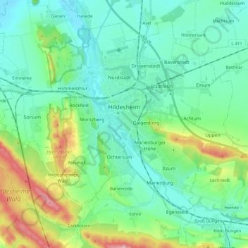
Name: Hildesheim topographic map, elevation, terrain.
Location: Hildesheim, Landkreis Hildesheim, Lower Saxony, Germany (52.09358 9.84655 52.19391 10.04285)
Average elevation: 120 m
Minimum elevation: 66 m
Maximum elevation: 298 m
Other topographic maps
Click on a map to view its topography, its elevation and its terrain.
Alfeld (Leine)
Germany > Lower Saxony > Landkreis Hildesheim
Alfeld (Leine), Landkreis Hildesheim, Lower Saxony, 31061, Germany
Average elevation: 191 m
Detfurth
Germany > Lower Saxony > Landkreis Hildesheim > Bad Salzdetfurth
Detfurth, Bad Salzdetfurth, Landkreis Hildesheim, Lower Saxony, 31162, Germany
Average elevation: 158 m
Nordstemmen
Germany > Lower Saxony > Landkreis Hildesheim
Nordstemmen, Landkreis Hildesheim, Lower Saxony, 31171, Germany
Average elevation: 100 m