
Alzey topographic map
Interactive map
Click on the map to display elevation.
About this map
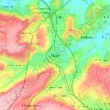
Name: Alzey topographic map, elevation, terrain.
Location: Alzey, Landkreis Alzey-Worms, Rhineland-Palatinate, Germany (49.71895 8.04044 49.77237 8.16632)
Average elevation: 222 m
Minimum elevation: 149 m
Maximum elevation: 307 m
Other topographic maps
Click on a map to view its topography, its elevation and its terrain.
Osthofen
Germany > Rhineland-Palatinate > Landkreis Alzey-Worms
Osthofen, Wonnegau, Landkreis Alzey-Worms, Rhineland-Palatinate, 67574, Germany
Average elevation: 105 m
Wöllstein
Germany > Rhineland-Palatinate > Landkreis Alzey-Worms > Wöllstein
Wöllstein, Landkreis Alzey-Worms, Rhineland-Palatinate, 55597, Germany
Average elevation: 153 m