
Aalen topographic map
Interactive map
Click on the map to display elevation.
About this map
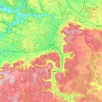
Name: Aalen topographic map, elevation, terrain.
Average elevation: 554 m
Minimum elevation: 359 m
Maximum elevation: 771 m
The elevation in the centre of the market square is 430 m (1,410 ft) relative to Normalhöhennull. The territory's lowest point is at the Lein river near Rodamsdörfle, the highest point is the Grünberg's peak near Unterkochen at 733 m (2,405 ft).[5]
Other topographic maps
Click on a map to view its topography, its elevation and its terrain.
Untere Eisengrube
Germany > Baden-Württemberg > Ostalbkreis > Essingen
Untere Eisengrube, Essingen, Verwaltungsgemeinschaft Aalen, Ostalbkreis, Baden-Württemberg, 73457, Germany
Average elevation: 644 m
Schwäbisch Gmünd
Germany > Baden-Württemberg > Ostalbkreis
Schwäbisch Gmünd, Verwaltungsgemeinschaft Schwäbisch Gmünd, Ostalbkreis, Baden-Württemberg, Germany
Average elevation: 460 m
Lorch
Germany > Baden-Württemberg > Ostalbkreis
Lorch, Ostalbkreis, Baden-Württemberg, 73547, Germany
Average elevation: 388 m