
Blankenburg (Harz) topographic map
Interactive map
Click on the map to display elevation.
About this map
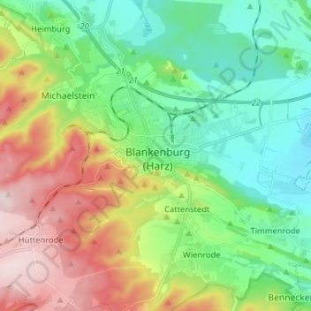
Name: Blankenburg (Harz) topographic map, elevation, terrain.
Average elevation: 272 m
Minimum elevation: 148 m
Maximum elevation: 500 m
Die Stadt Blankenburg (Harz) liegt dicht am Nordrand des Harzes in etwa 234 m Höhe. Blankenburg (Harz) befindet sich westlich von Quedlinburg, südlich von Halberstadt und östlich von Wernigerode. Der Goldbach fließt durch den nordwestlich des Stadtzentrums gelegenen Stadtteil Oesig.