
Neustadt in Holstein topographic map
Interactive map
Click on the map to display elevation.
About this map
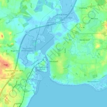
Name: Neustadt in Holstein topographic map, elevation, terrain.
Average elevation: 10 m
Minimum elevation: -6 m
Maximum elevation: 53 m
Other topographic maps
Click on a map to view its topography, its elevation and its terrain.
Pönitz am See
Deutschland > Schleswig-Holstein > Kreis Ostholstein > Scharbeutz
Average elevation: 25 m
Anschottredder
Deutschland > Schleswig-Holstein > Kreis Ostholstein > Bujendorf
Average elevation: 51 m
Burg auf Fehmarn
Deutschland > Schleswig-Holstein > Kreis Ostholstein > Fehmarn
Average elevation: 6 m
Pelzerhaken
Deutschland > Schleswig-Holstein > Kreis Ostholstein > Neustadt in Holstein
Average elevation: 8 m