
Ottweiler topographic map
Interactive map
Click on the map to display elevation.
About this map
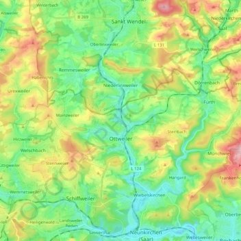
Name: Ottweiler topographic map, elevation, terrain.
Location: Ottweiler, Landkreis Neunkirchen, Saarland, 66564, Germany (49.38435 7.09076 49.44109 7.29285)
Average elevation: 329 m
Minimum elevation: 236 m
Maximum elevation: 513 m
Other topographic maps
Click on a map to view its topography, its elevation and its terrain.
Eppelborn
Germany > Saarland > Landkreis Neunkirchen
Eppelborn, Landkreis Neunkirchen, Saarland, 66571, Germany
Average elevation: 297 m
Neunkirchen
Germany > Saarland > Landkreis Neunkirchen > Neunkirchen
Neunkirchen, Landkreis Neunkirchen, Saarland, 66538, Germany
Average elevation: 280 m
Illingen
Germany > Saarland > Landkreis Neunkirchen
Illingen, Landkreis Neunkirchen, Saarland, 66557, Germany
Average elevation: 331 m
Schiffweiler
Germany > Saarland > Landkreis Neunkirchen
Schiffweiler, Landkreis Neunkirchen, Saarland, 66578, Germany
Average elevation: 314 m