
Peine topographic map
Interactive map
Click on the map to display elevation.
About this map
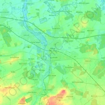
Name: Peine topographic map, elevation, terrain.
Location: Peine, Landkreis Peine, Lower Saxony, Germany (52.25810 10.11768 52.37449 10.34838)
Average elevation: 74 m
Minimum elevation: 58 m
Maximum elevation: 111 m
Other topographic maps
Click on a map to view its topography, its elevation and its terrain.
Hohenhameln
Germany > Lower Saxony > Landkreis Peine
Hohenhameln, Landkreis Peine, Lower Saxony, 31249, Germany
Average elevation: 77 m
Lengede
Germany > Lower Saxony > Landkreis Peine
Lengede, Landkreis Peine, Lower Saxony, 38268, Germany
Average elevation: 87 m